All in One View
Content from Introduction
Last updated on 2026-07-28 | Edit this page
Estimated time: 12 minutes
The hackathon invites participants to explore how digital data sources can be combined to address research questions related to global challenges and cultural heritage. The hackathon is designed as a series of activities collaboratively exploring data and computing across Digital Research Infrastructure (DRI) to pilot innovative research directions.
The integration of data from heterogeneous sources is explored through a series of use cases or scenarios, which touch on different infrastructures, tools, disciplinary perspectives and skills. While the hackathon proposes a set of scenarios, participants are encouraged to think expansively. While doing so, participants are invited to reflect on the strengths and needs of these data services, the availability of tools, and the knowledge barriers to developing research approaches based on these infrastructures. The role of Artificial Intelligence models in supporting coding and agentic processes in software development is of further interest.
During the hackathon, participants gain practical knowledge and insights into data services, community-generated code, and innovative AI-assisted methods.
To design a scenario, we will go through the following steps:
Step 1: Familiarisation with the scenarios
Read the summary of each scenario, as it sets out a proposed context and general theme to be investigated, and begin shaping your research questions.
Step 2: Find data
Explore the proposed datasets and others in the DRI services to identify suitable datasets, sub-datasets and associated metadata that can potentially help address your research question/s.
Step 3: Create a dataset: Merging, cleaning and storing
Explore how can the data be combined data including using languages such as Python, AI models and visualisation tools, to support decision-making and interpretation.
Step 4: Update the github repo
Using the findings, update the repositoy for this resource to record and communicate to other the progress for this scenario.
Challenge: Use the following guiding questions during the day:
- What research questions have you identified?
- Why are they important in the context of your chosen scenario?
- Which data need to be linked to address your research question/s?
- What are the main challenges faced when working with these infrastructures?
- How could the developed or envisaged workflows, and the addressing of research question/s, benefit the economy, society, or support the SDGs?
Content from Scenarios
Last updated on 2026-07-28 | Edit this page
Estimated time: 12 minutes
Scenarios
The scenarios below can inform the development of workflows or research ideas. They aim to leverage the availability and integration of relevant information from different data services.
Prioritising emergency recording of cultural heritage
Coastal heritage sites face growing threats from erosion, flooding, and climate change, making equitable, data-driven prioritisation of preservation resources essential.
Informing planning of infrastructure affecting cultural heritage
Infrastructure near heritage sites boosts tourism and access but risks physical damage and overtourism; decision-makers need better data to balance these pressures.
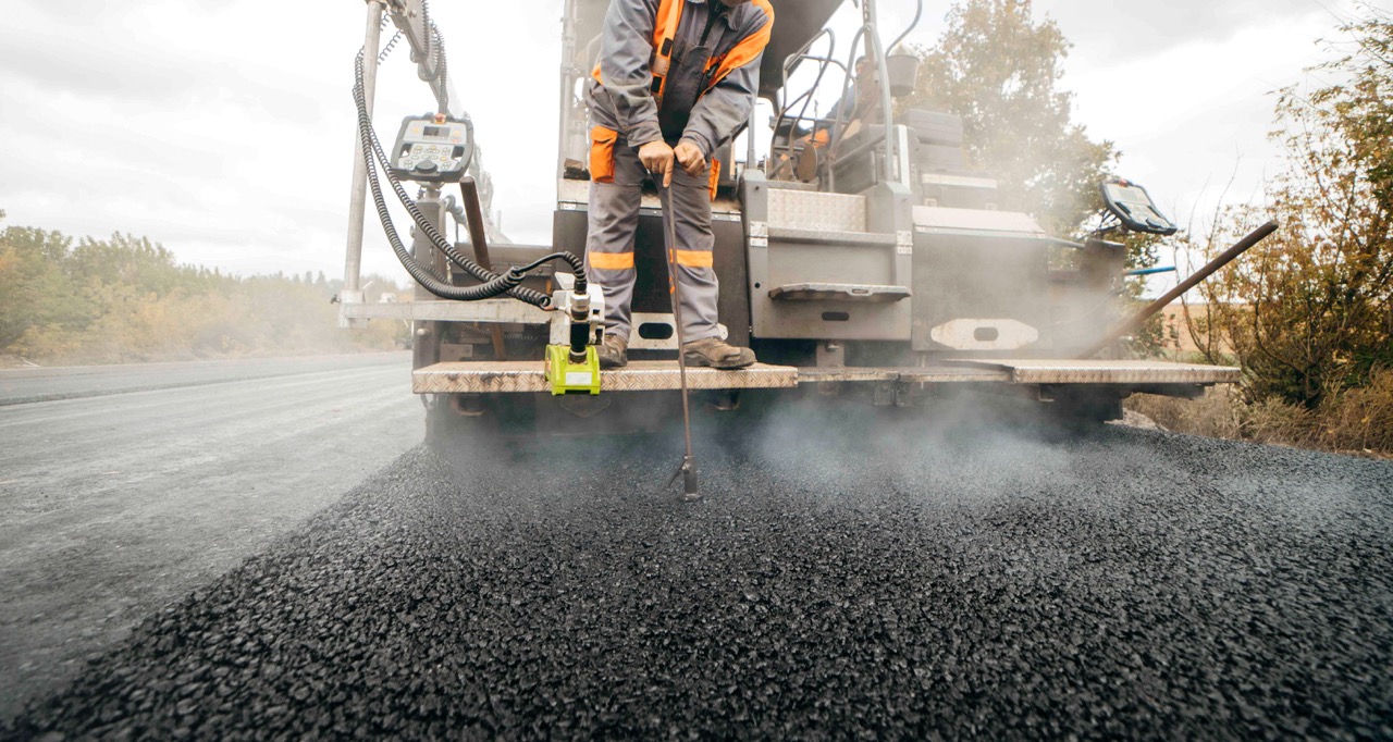
Mitigating the impacts of ageing infrastructure on urban communities
Urban historic buildings face structural damage from traffic and ageing infrastructure, threatening occupied spaces and requiring better data to guide mitigation planning.
Mapping Seshat data to historical polities with Cliopatria
Quantitative historical data in Seshat can support powerful comparative research, but the lack of explicit and precise geographic data limits spatial analysis. Combining Seshat with Cliopatria polygon data makes it possible to map polities, identify gaps in coverage, and explore likely transitions between political entities over time.
Content from Prioritising emergency recording of cultural heritage
Last updated on 2026-07-28 | Edit this page
Estimated time: 12 minutes

Summary
Coastal cultural heritage—including archaeological sites, historic buildings, and maritime landscapes—is increasingly at risk of erosion, flooding, climate change, and human activity. These threats are often rapid and uneven, making it difficult for heritage professionals to determine where limited resources for documentation and preservation should be focused. Incorporating socio-economic data can also support prioritising areas with social, economic or cultural importance, while also improving equity in heritage preservation.
ADS Datasets
CITiZAN: the Coastal and Intertidal Zone Archaeological Network
Citizen science collected dataset of heritage sites under threat.
- Digital Collection - CITiZAN, Museum of London Archaeology (2024) CITiZAN: the Coastal and Intertidal Zone Archaeological Network [data-set]. York: Archaeology Data Service [distributor] https://doi.org/10.5284/1116909
- .csv download of database
- Entire dataset via ADS Catalogue
- DAFNI upload - CITiZAN: the Coastal and Intertidal Zone Archaeological Network dataset of sites around England.
Rapid Coastal Zone Assessment Surveys (RCZAS) — Historic England
- Digital Collection - Historic England (2013) Rapid Coastal Zone Assessment Surveys (RCZAS) [data-set]. York: Archaeology Data Service [distributor] https://doi.org/10.5284/1106880 > Note: Made up of a series of surveys around the English coastline.
The Palaeolithic Rivers of Southwest Britain
- Collection - Tony Brown, Robert Hosfield, Laura Basell, Phil Toms, S. Hounsell, R. Young (2008) The Palaeolithic Rivers of Southwest Britain [data-set]. York: Archaeology Data Service [distributor] https://doi.org/10.5284/1000027
- DAFNI upload - The Palaeolithic Rivers of Southwest Britain: Artefacts and Findspots
Inland Navigation in England and Wales before 1348: GIS Database
- Collection - Oksanen, E. (2019) Inland Navigation in England and Wales before 1348: GIS Database [data-set]. York: Archaeology Data Service [distributor] https://doi.org/10.5284/1057497
- DAFNI upload - Inland Navigation in England and Wales before 1348: GIS Database
Summer Precipitation for the England and Wales region, 1201–2000 CE, from Stable Oxygen Isotopes in oak tree rings
- Collection - N. J. Loader, G. H. F. Young, D. McCarroll, D. Davies, D. Miles, Christopher Bronk Ramsey (2020) Summer Precipitation for the England and Wales region, 1201–2000 CE, from Stable Oxygen Isotopes in oak tree rings [data-set]. York: Archaeology Data Service [distributor] https://doi.org/10.5284/1078324 (spreadsheet data)
- Associated publication - Loader, N.J., Young, G.H.F., McCarroll, D., Davies, D., Miles, D., and Bronk Ramsey, C. (2020), Summer Precipitation for the England and Wales region, 1201–2000 CE, from Stable Oxygen Isotopes in oak tree rings. J. Quaternary Sci. https://doi.org/10.1002/jqs.3226
- DAFNI upload - Summer Precipitation for the England and Wales region, 1201 - 2000CE, from Stable Oxygen Isotopes in oak tree rings
DAFNI Datasets
CGFI
- Aqueduct Flood Hazard Maps from WRI (United Kingdom) CGFI-GRI https://facility.secure.dafni.rl.ac.uk/data/details?dataset_id=70325cc5-b846-4e47-8a00-5867b[…]80b7&metadata_id=1ef456a4-89fa-4c7a-a765-ec5cefeea841
- Tropical cyclone wind speed return period maps using STORM (United Kingdom) CGFI-GRI https://facility.secure.dafni.rl.ac.uk/data/details?dataset_id=435e52bc-fc0e-4643-a5a0-83ca1[…]d6e6&metadata_id=89ad654e-5de5-4dd9-95a1-4b649a6ff86e
Content from Informing planning of infrastructure affecting cultural heritage
Last updated on 2026-07-28 | Edit this page
Estimated time: 12 minutes
Summary
The development of infrastructure around cultural heritage sites presents a complex balance between improving access and safeguarding fragile assets. New transport links and utilities can increase visitor numbers and bring economic benefits to local communities, particularly through tourism. However, these same developments can place significant pressure on heritage sites, leading to physical damage, erosion, and the risks associated with overtourism. Decision-makers often lack a holistic view of how planned or future infrastructure projects will interact with both existing and potential heritage sites.
ADS Datasets
HS2 Heritage Spatial Archive
- Collection - High Speed Two Ltd. (2024) HS2 Heritage Spatial Archive [data-set]. York: Archaeology Data Service [distributor] https://doi.org/10.5284/1118851
- Part of a parent collection - High Speed Two Ltd. (2023) HS2 Historic Environment Digital Archive [data-set]. York: Archaeology Data Service [distributor] https://doi.org/10.5284/1113008
- Associated data paper - Aryankhesal, F.F. 2023 ‘HS2 Phase One: Heritage GIS Digital Archive (Data paper)’, Internet Archaeology, HS2 publications. https://doi.org/10.11141/ia.hs2.1
- DAFNI upload - HS2 Heritage Spatial Archive - LiDAR survey and GIS data.
A14 Cambridge to Huntingdon, Cambridgeshire Improvement Scheme: Digital Archive for Archaeological Works
- Collection - MOLA Headland Infrastructure (2025) A14 Cambridge to Huntingdon, Cambridgeshire Improvement Scheme: Digital Archive for Archaeological Works [data-set]. York: Archaeology Data Service [distributor] https://doi.org/10.5284/1081262
- Associated monograph - West, E., Christie, C., Moretti, D., Scholma-Mason, O. and Smith, A. 2024 A Route Well Travelled. The Archaeology of the A14 Huntingdon to Cambridge Road Improvement Scheme, Internet Archaeology 67. https://doi.org/10.11141/ia.67.22
DAFNI Datasets
CGFI
- Road and Rail networks derived from OpenStreetMap (United Kingdom) CGFI-GRI https://facility.secure.dafni.rl.ac.uk/data/details?dataset_id=2f738469-f946-404b-b7e2-1693f[…]fd23&metadata_id=e1e2cf89-cc60-4931-a048-21f4d85440e5
- Residential population density map: past and projected (United Kingdom) CGFI-GRI https://facility.secure.dafni.rl.ac.uk/data/details?dataset_id=ea5d9b8c-ad63-4c5f-a499-c70f5[…]22b6&metadata_id=b72a72ec-9a24-4b39-bc4c-66d7584b9384
Content from Mitigating the impacts of ageing infrastructure on urban communities
Last updated on 2026-07-28 | Edit this page
Estimated time: 12 minutes

Summary
Listed and historic buildings in urban areas are particularly vulnerable to the impacts of ageing infrastructure, including transport networks, underground utilities, and adjacent buildings. Continuous exposure to vibration from rail and road traffic, alongside ground disturbance from maintenance or redevelopment, can weaken structural integrity, causing cracking, settlement, and material fatigue in historically sensitive fabric. These can have a significant impact on how such buildings are used—often still occupied as homes, workplaces, or community spaces—directly affecting users’ lived experience. Understanding how ongoing stress can affect these fragile, historically significant structures can support planning interventions and other mitigation strategies.
ADS Datasets
Vernacular Architecture Group (VAG) Collections and Map
- Entire Collection - Vernacular Architecture Group (VAG) (2024) Vernacular Architecture Group (VAG) Collections and Map [data-set]. York: Archaeology Data Service [distributor] https://doi.org/10.5284/1106888
- Interactive map (no downloadable GIS files, but each dataset can be downloaded as structured data)
- DAFNI upload - Vernacular Architecture Group databases of traditional buildings location and features.
DAFNI Datasets
CGFI
- Global Power Plant Database from WRI (United Kingdom) CGFI-GRI https://facility.secure.dafni.rl.ac.uk/data/details?dataset_id=50f01d72-87ff-4270-89aa-6ca13[…]840c&metadata_id=93e5c77a-4d7f-4521-95d9-e8c2064f7777
- Estimated electricity access levels using Gridfinder (United Kingdom) CGFI-GRI https://facility.secure.dafni.rl.ac.uk/data/details?dataset_id=f7659972-0ff4-44b2-b890-82b89[…]4ad0&metadata_id=fdbe77d8-4b06-46c7-97f6-01aad85cdd41
- Human settlement boundaries including settlement characteristics (United Kingdom) CGFI-GRI https://facility.secure.dafni.rl.ac.uk/data/details?dataset_id=fa7151de-17e3-4cf2-8ea6-f3058[…]8443&metadata_id=03fe38cf-a0b4-48f3-a4c7-1f1621b862d5
- Road and Rail networks derived from OpenStreetMap (United Kingdom) CGFI-GRI https://facility.secure.dafni.rl.ac.uk/data/details?dataset_id=2f738469-f946-404b-b7e2-1693f[…]fd23&metadata_id=e1e2cf89-cc60-4931-a048-21f4d85440e5
Content from Mapping Seshat data to historical polities with Cliopatria
Last updated on 2026-07-28 | Edit this page
Estimated time: 12 minutes
Summary
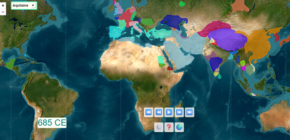
Seshat Global History Databank is a large-scale, collaborative research dataset designed to systematically encode historical and archaeological knowledge about human societies. It covers societies from the Neolithic period to the present and includes uncertainty estimates and qualitative context. This makes Seshat suitable for quantitative analysis, but also introduces challenges related to incompleteness, ambiguity, and uneven coverage across regions and time.
The data in Seshat is grouped by polity and associated with time ranges and degrees of certainty. However, it is missing a crucial component: explicit geographical extent. This can be addressed by integrating a second dataset, Cliopatria, which provides polygonal boundaries for polities in GeoJSON format from 3400 BCE to the present.
Building a tool that maps Seshat data onto Cliopatria shapefiles enables several forms of analysis:
- Visualise which polities present in Cliopatria are missing in Seshat, and assess whether omissions are systematic, for example regional or temporal.
- Identify likely successor and predecessor relationships based on geographic overlap, temporal continuity, language, or religion.
- Explore how combining structured historical data with spatial boundaries supports richer comparative analysis.
This scenario introduces users to working with the Seshat databank,
including the Seshat API, while developing practical skills in handling
large structured datasets with pandas and geospatial data
with geopandas.
ADS Datasets
No Archaeology Data Service dataset has been listed for this scenario yet.